Drone Services for Insurance Claims
Professional Drone Services for Insurance Inspections and Claims
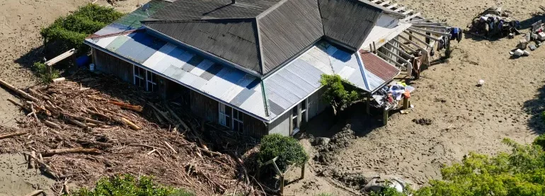
Get a closer look without the hassle, delays or risk
Large areas of land can easily be photographed, examined, and documented by drones to capture an exact reading of their geography, boarders, and vegetation cover. This allows you to record a professional and accurate status of your land at a given point in time, without having to step foot on the ground.
Our drones can monitor huge areas of land in a single flight, something that was previously only possible via satellite. Drones give you higher quality imagery and more useable survey data, faster and with fewer challenges.
Using drones equipped with 3D modelling technology, you can quickly and accurately inspect stockpile volumes, eliminate guesswork from tonnage measurements, and track the progress of your site over time.
The use of drone 3D modelling technologies gives you the opportunity to inspect a digital twin of a an asset from the comfort of your office. This detailed replica can be inspected at a minute level, allowing you to make a record of any areas that are in need of attention. Issues such as poorly executed repairs, general damage and other potential weaknesses can be shared with your employees, suppliers and other shareholders at the click of a button.
Our drones can capture the minute details of any object, without having to touch or even get close to it. Objects that once had to be shut down, climbed and traversed can now be inspected and monitored in real time more quickly, and with zero risk to personnel.
Why Use A Drone For Building Inspection?
No scaffolding or ropes
Drone technology is cheaper, safer and more reliable than traditional methods such as scaffolding, cherry-pickers and ropes. It's also quicker and less labour intensive. We will bring everything we need and be out of your way that same day.
Detect hidden problems
We use cutting-edge technologies to detect problems that would otherwise be invisible. These include ultra-HD photography/video, LIDAR and thermal.
No traffic disruption
Downtime is expensive, unpopular and inconvenient. Using a drone, we can conduct a thorough survey with little to no downtime.
Safety
The safety of your personnel and our own is paramount, and we place it at the forefront of our company culture. Ask us about our OSH systems and practices.
No risk to your assets
Our equipment won't touch or even go close to your assets. Our high-resolution cameras use optical zoom to give extreme close-up views while staying a safe distance away.
Rapid response
Need us there in a hurry? No problem. Let us know what you need, and we can be there on the same day. After all, sometimes the problem just won't wait.
How Does It Work?
1. Reach out and tell us your idea
We take emails, phone calls, messages, everything! If you are unsure of what’s possible we are happy to advise, the most important thing is to get in touch. We would be delighted to answer any questions you may have.
2. Start at the end
With drones, it’s best to begin where you want to end up. What sort of deliverable would you like when it’s all finished? If you are not sure then we can advise. We can look at what you would like and work backwards from there.
3. Scope of work and set a price
Once we have agreed on what is to be done, the scope of work is set and a price is agreed upon. We feel it is vital that everyone knows what they are getting and what they are paying for it. There should be no confusion.
4. Permits and other paperwork
Once we have confirmation you are happy to proceed, we start the ball rolling. We organise things like RAMS, site permits, Air Traffic Control clearance and much more. Basically, we generate everything needed to turn up on-site with all our ducks in a row
5. Field Operations
Next, we do the work on site. We have the gear, we have the know-how, so now it’s time to get the job done. This can sometimes be affected by the weather, but for the most part, we get the job done on the date specified.
6. Post Processing
This is where we take what we generated in the field and turn it into a final deliverable for you. This can be anything from the raw data itself, to fully processed orthophotos, condition reports, CAD line work or thermal imagery.
7. Handover
The final step is the handover of the deliverables. We tend to use a cloud-based service, so you can access your data anywhere. We can also tie into your existing systems if that is more convenient.